The planning for my trips will be very much superficial, till the last minute; I will not decide on the places to visit until then. The Saturday evening was also not special. Finally at 9-00 pm, I had done the rough plan and the places to visit (though we could not cover all the places at the end). Finally, after a couple of phone calls to Keshav & Manju, our plan was finalized. Next day morning, 19, June, 2011, we were ready to vroom, started from Indiranagar at 7-45 am, with 3 of us in my Ritz Vxi (me, Prasad, Manju), picked up Keshav on the way near the Mekhri circle, hit the Tumkur Road at Yeshwantpur. I was not disturbed by the traffic during the morning peak hours, even though we ran late by 45 minutes from our plan, thanks to Sunday for having a less traffic at 8-30 am in the morning. This is my first long drive in my Ritz since odometer crossed 2000 km. I was testing my car with different RPM’s throughout the journey on the Tunmkur road. We had our breakfast at Kamat Upachar near Dobbaspet. Since there are no good hotels nearby, these people are charging heavily for the quality of food & service they are providing. Nevertheless, we filled our stomach full and started moving with stereo on. In Dobbaspet, we should enter the town (do not take the fly over), deviate to the right with sign board showing the way to Madhugiri. Here onwards, the traffic was very less, pleasant driving on roads with Rocky Mountains on either side, with thin forest cover at some places. We reached Namada Chilume after taking deviation at Uradigere and another deviation at unknown location (No worry, there are sign boards) in an hour drive from Dobbaspet.
 |
| Tumkur road |
Namada Chilume :
We paid the entry fee of 12 INR for four of us which pushed me to a real good surprise. Soon it was justified by the places to see inside! There is a Jinke Vana (Deer Park), with different varieties of Deer. Luckily one was very bold and was getting the feed from us. I was able to touch a deer for the first time in my life. After walking around 250 meters into the park, there is a rock where in water was oozing out. It is believed that Rama shot an arrow onto the rock to get water to apply Nama/Tilak on his face. That’s how the name was derived for this place. There is a botanical garden too, which we skipped as we were running late to reach Devarayana Durga.
 |
| Namada Chilume |
 |
| Jinke Vana |
Devarayana Durga :
The drive was in a ghat section kind of road with couple of hair pin curves and it is 7 km away from our previous destination. Like other hills nearby Tumkur, here also there is a temple at the top and is crowded. We went to the temple, had darshan of God Yoganarasimha, and we headed to the peak. Here there was no clear path/way unlike the way to the temple was facilitated by steps. We could enjoy the beauty of vastness from here peacefully. Most of the people will return from the temple, hence this place is tidy & clean. It is worth the effort for climbing. We spent some time here and started our descend to reach Madhugiri.
 |
| View from top of Devarayana Durga |
 |
| Green cover in the rocky world |
 |
| Yoganarasimha temple |
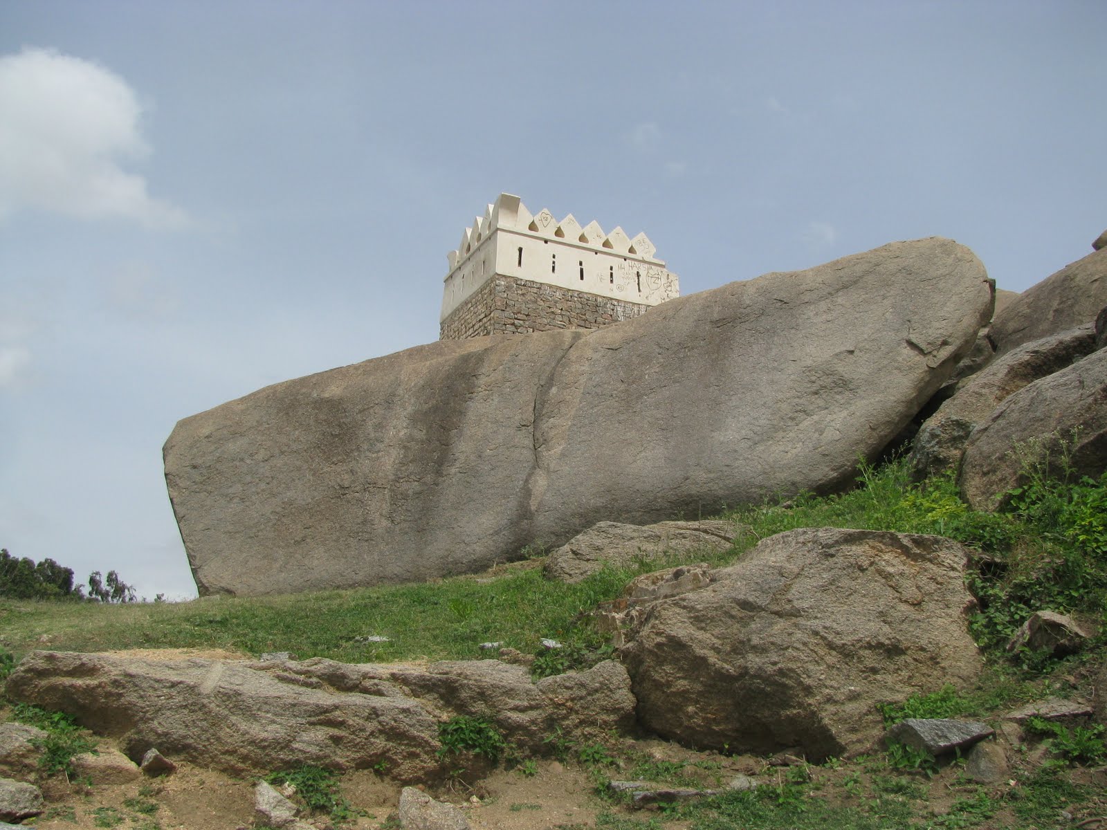
Madhugiri :
It is around 60 km from Devarayana Durga, the road till Koratagere is good, but from Koratagere to Madhugiri is bad. There are quite a lot of humps in the road without any markings, so should be very cautious while driving. After driving for about an hour, we reached Madhugiri at 1-30 pm. We had our lunch at a hotel inside the KSRTC bus stand guided by a local GPS. While having our lunch, we were planning to cover the trek to Madhugiri rock not more than an hour. What a foolish guys we are!
 |
| Building with out any foundation |
 |
| Start of climb to Madhugiri |
There is a fort built on this hill in a step design, due to which, we can not guess the distance to cover to reach the peak. We will be able to see the peak of each stage, after scaling it up, we could see the next peak, thus on and on.. Unaware of all these fact, we started our trek with full meal energy. Initial path was well maintained with proper steps to climb & It was easy. The next stage was bit tougher but could manage easily for youngsters like us! In the third stage, which we thought is the final climb, was a bit steep and the path was along the rock edge. Here Keshav decided to quit due to fear of height problem. We tried to convince him very hard but in vein. He returned from here with our assurance that we will be back in half an hour as the peak was visible from there. Once we finished the third stage and entered the fort through the door, we were invited to climb the same distance as we had already climbed from the base. Prasad and Manju wanted to give up as there was no steps from here on, but I had decided to continue, so started moving on very slowly. Then both of them joined and came along. Slowly we inched forward, crossed the fourth stage. Oops! Still we have not reached the peak. Took a break here, started moving up, and finally here we go, at the top with out any surprises(we were surprised that we reached the peak). We explored the abandoned temple at the top and at the back side of the temple, surprised to find a small lake with out any water source. We took a long break here for about 45 minutes. The scenic view from the top is really fantastic, and is worth the effort of climbing the rock for complete two hours. We could feel the vastness of earth for some extent, the entire Madhugiri town was looking very small, houses were looking like match boxes scattered here and there. It was very peaceful sitting on Asia’s highest monolith rock, gazing at huge rocky mountains at the far end surrounding you, yet not thinking anything. Kind of sleep, but enjoying it lively. It was around 4-45 pm and we started descending down. Descending is always easy compared to climbing up and thus we could climb down the hill in an hour or so. As we drove back, the huge rock was running behind us as if we are going to destroy it, and finally it ran away from our eye sight in 15 minutes.
 |
| View from top of Madhugiri rock |
 |
| Lake at the top |
 |
| Storage places of the Royal's time |
 |
| Final layer of the fort |
 |
| Guys struggling to descend ! |
 |
| Half way down |
 |
| Madhugiri town decimated |
 |
| The route across the rock induces some fear (Keshav had to quit) |
 |
| The famous structure |
I had an amazing drive back to Bangalore with the scenic of sun bidding good bye and dusk was taking over, in front of me. Soon I had to switch on the headlights and entered Tumkur - Bangalore highway. From here on, I just played NFS5 (Game which I played the most) with two just misses though I won the game (For winning the game, I have to admit, along with my gaming skills, other guys safe luck also mattered).
Route :
Bangalore -> NH4 -> Dobbaspet -> SH3 -> Uradigere -> Take Left -> Namada Chilume Rd -> Namada Chilume -> continue in the Namada Chilume Rd -> Take right at the first junction -> First left -> Devarayana Durga -> Come back in the same road -> Take first left -> SH3 -> Koratagere -> Madhugiri
General Information :
- Just before the Dobbaspet flyover, there is Kamat Upachar, where you can get different varieties of food
- The total distance is around 225 km, no need of search for the petrol pumps
- After Kamat Upachar you can have food at Madhugiri (Taste is OK, but not hygiene)
- Koratagere town is bigger than Madhugiri, so you can try out for good restaurants here(I am not sure)
(Thanks to Manjunath for some of the photos)


No comments:
Post a Comment